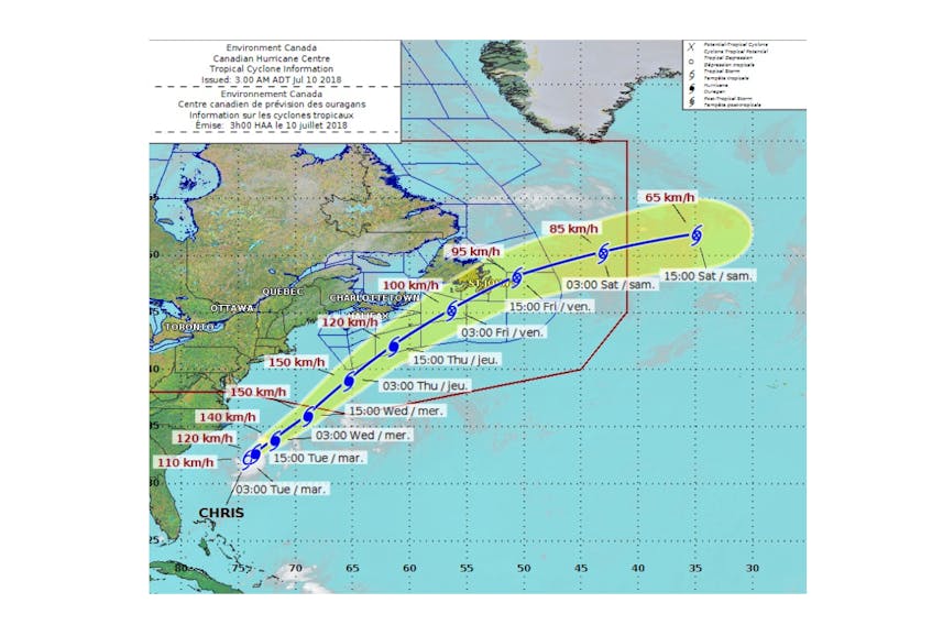
The most recent weather models have tropical storm Chris intensifying to a full hurricane on Tuesday and following a track that will pass between Sable Island and Nova Scotia on Thursday.
Bob Robichaud of the Canadian Hurricane Centre said as of Monday afternoon it’s looking more likely that the storm will brush the Eastern Shore and Cape Breton, although he cautioned that the margin for error in these predictions is wide.
“You’re still looking at several hundred kilometres on either side of the track as to where this thing could go, so we can’t rule out landfall on Nova Scotia but it looks like the centre, at least, of the storm will stay offshore,” Robichaud said in a telephone interview.
“Now, that still might bring us some rain and windy conditions during the day on Thursday but just how strong and how much rain remains to be seen.”
The storm is expected to intensify but then lose some
strength again as it moves northeast.
As of Monday afternoon, the storm was about 300 kilometres southeast of Cape Hatteras, North Carolina.
“And it’s not really moving a whole lot right now,” Robichaud said. “It’s kind of meandering off the coast there.”
Chris will pick up steam and begin moving soon enough, however.
“We expect that the storm will start to move a lot faster towards the northeast by late in the daytomorrow (Tuesday) and that would bring it off the coast of Nova Scotia on Thursday.”
There are still a lot of question marks related to the timing of when the storm will affect Nova Scotia, Robichaud said.
“Would it be overnight or early morning Thursday or later on Thursday? That still remains to be the question.
“And for right now it looks like the storm will track between Sable Island and Nova Scotia but come closest to the Eastern Shore and Cape Breton.”
The biggest factor that will influence the track Chris ultimately follows is an upper trough of low pressure. “Basically (that’s) the jet stream that’s to the west of the storm,” Robichaud explained.
“As that approaches the storm itself, that is going to be what actually steers and pushes the storm from where it is now up towards the northeast. So the timing of that trough and the shape of that trough is going to dictate when it actually starts moving and where exactly it’s going to go from that point on.”
Environment Canada’s latest advisory says that “by late Tuesday it is forecast to attain hurricane status. At this time it appears this storm could approach Nova Scotia by Thursday, likely weakening slightly as it does so.”
It notes that “there is a good deal of uncertainty at this time in the forecast track and intensity of this system” but expects that if the track stays as forecast that it will begin to issue storm bulletins starting Tuesday morning.
Chris had top winds of 95 kilometres an hour on Monday as it lingered off the U.S. It was far enough out to sea that no coastal watches or warnings were in effect.
Robichaud said Chris is the third named storm of the spring.
“We had Alberto that actually formed before the season started and then we had Beryl that actually formed last week, so we’ve had two named storms here in the span of about four days here in July. So we’re near or slightly above where we should be for an average year as it relates to tropical storms and hurricanes.”
Beryl disintegrated shortly before reaching Dominica, where many people still shelter under tarps on their roofs more than nine months after hurricane Maria hit as a Category 5 storm and killed dozens of people. The storm’s remnants crossed directly over the island with top sustained winds of 65 kilometres per hour and was expected to drop up to eight centimetres of rain, with as much as 13 centimetres in isolated spots.
With the Associated Press